For a new touring rider, planning is an essential component of a successful first tour. Some riders may enjoy intentionally getting lost on back roads while exploring their home countryside. Long distance riding, however, can easily lose its fun factor without proper planning. Many new touring riders wrongly write off long distance riding after one trip. What they do not realize is that they dislike their failure to properly plan, not long distance riding itself. For those reading this who have had a bad experience with touring, follow the advice below and give it another try. For new touring riders, hopefully this advice will allow you to never know the pain of a poorly planned tour.
What you Need Before You can Plan
In order to properly plan a tour, a rider must be able to answer the following questions:
How many miles can your motorcycle cover on a tank of fuel?
This is one of the most important things to know about your motorcycle, whether you are touring or just riding around town. Even though motorcycles are a lot easier to push than cars, running out of gas is a real inconvenience. The inconvenience is exacerbated on a long trip, and can even become dangerous. Out west, gas stations can be 50 or 100 miles apart, even along interstates. If you pass an exit with a gas station, and do not know when the next one will come up, you are playing Russian roulette with your trip. Being “pretty sure” you can make it to the next stop is not good enough. Chancing it can leave a rider with a long walk (think 50+ miles) to get gas, and can leave them exposed to the elements or wildlife with no means of escape. A motorcycle will easily outrun a mountain lion or bear. Unless your name is Usain Bolt, I guarantee you that you cannot.
When I say “tank of fuel”, I am referring to the main tank, or the tank before it goes onto reserve. For carbureted bikes, this is usually when the fuel level gets low enough that the rider has to switch from “main” to “reserve” on the petcock. For fuel-injected bikes or bikes with a fuel gauge, this is when the fuel light comes on or the gauge is reading near the bottom. The reserve fuel is meant to be a cushion in case your bike is using more fuel than normal, or you get stuck in several long traffic jams that eat into your fuel economy.
To figure your bike’s fuel range, fill your motorcycle’s tank and go for a ride. Stay on roads you know well and ride until you get your motorcycle’s low fuel warning occurs (petcock/light/gauge). Repeat this process two or three times (not necessarily on the same day) to get several different results and get a general idea of fuel range. Do not worry about how often you need to stop and get off the bike for this part. Your only goal is to see how far your motorcycle can go before you have to refuel.
Some motorcycle tend to have wider variations in fuel range than others. My old Suzuki Bandit 1200 would get somewhere between 150 and 165 miles on a 4.2-gallon main tank before I went onto reserve. My FJR1300 was not as consistent, but would stay somewhere between 210 and 240 miles per tank (5.3-gallon main tank) depending on ambient temperature and how fast I was riding. The Ninja 500 I used this past summer after my accident had a bit more variation in its fuel range. I would get anywhere from 175 to 215 miles per tank (4.2-gallon main tank).
How long can you ride before you need to stop?
Once you know how far the motorcycle will go on a tank of fuel, a rider needs to figure out what their fuel range is. Many long-distance riders, like myself, like the idea of riding from fuel stop to fuel stop. This limits the amount of time spent off the bike and saves a lot of time. However, every rider is different, and new riders need to be especially conscious of this. Getting tired behind the bars is not the same as getting tired behind the wheel of a car. Drifting off while driving is dangerous enough, but car drivers do not have to worry about keeping their cars balanced. The need to keep a motorcycle balanced makes riding more physically and mentally demanding than driving, which in turn makes fatigue set in much sooner.
All riders who are new to touring need to go out on another couple rides after they figure out how far their bike will go on fuel to see how long they can comfortably ride. Just start riding away from home until you start to feel a little fatigued. Find a place to pull off and rest (like a gas station or diner), refuel the bike and body, then get back on and head toward home. Try to note if the fatigue starts to set in around the same time on the second part of the trip as it does in the first. Organizations like the Motorcycle Safety Foundation (MSF) recommend for no longer than two hours at a time (http://www.msf-usa.org/downloads/mom_v16_GS_low_res.pdf, page 45). I think that is a little conservative, but I personally try to not ride for longer than 3-3.5 hours at a time.
What kinds of roads are you planning on riding for your tour (interstate or back roads)?
The next step is figuring out how many miles you can reasonably cover in a day. For really short trips, this may not be a big deal. For example, a ride from Columbus, Ohio to Pittsburgh, Pennsylvania is only 3 hours each way. A rider can relatively easily leave around 7am, get into Pittsburgh around 1030am with a fuel stop, see all things Pittsburgh, and be back in Columbus at a reasonable hour. The problem arises when distance begins to increase. A rider can easily make it from Columbus, Ohio to Philadelphia’s western suburbs in a full day by interstate (7.5 hours riding time per Google Maps). If that same rider attempts to take all back roads to get to the same destination, they may find themselves arriving well after sunset (almost 13 hours of riding time).
Preparing the Plan
The best way to do trip planning is to use an online mapping site like Google Maps or Bing Maps. Online mapping allows a rider to easily play with route ideas and trip stops while getting updated trip mileage and riding time. While nearly everyone has used Google Maps to figure out who to get to a bank, repair shop or motorcycle rally, planning a multi-day, multi-stop trip is a more advanced process. Try following these steps:
Pick your overall starting point and destination
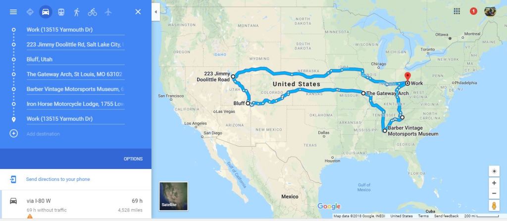
This part is pretty straight forward. Simply enter into Google Maps where your trip is starting from and what you final destination is. For demonstration purposes, let’s do a trip from the American Motorcyclist Association (AMA)’s headquarters outside of Columbus, Ohio (13515 Yarmouth Drive, Pickerington, Ohio 43147) to the Circuit of the Americas race track outside of Austin, Texas (https://goo.gl/maps/2gj1KtHHSb22).

There are two things to notice after getting directions from Google Maps. First, the trip would be 1,257 miles long using the most direct route. If your motorcycle has a fuel range of approximately 200 miles, a rider would be looking at approximately five fuel stops (six, 200-mile segments) during the total length of this trip. The second thing to notice is how many hours you will likely be on the road. In our example trip, it takes (on average) 18 hours and 34 minutes to reach Austin by interstate. For an experienced touring rider, this is likely a two-day trip. However, if you are a new touring rider, or find that you need to rest every hour and a half to two hours of riding, you may want to make this a three-day ride.
Pick your route
If we use the “Options” menu in Google Maps to select “Avoid Highways” and recalculate the route, we see a major change. While the trip mileage is essentially the same, the projected riding time has increase by approximately six hours.
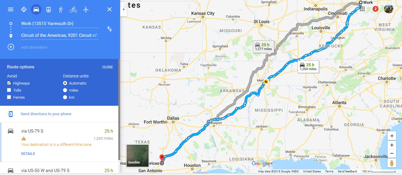
While a very experienced tourer may be able to tackle this trip in two days, choosing to stay off of interstates has greatly increased the time needed to comfortably complete the trip. There is nothing wrong with taking back roads, as they usually offer a combination of more fun roads to ride and more interaction with local culture. However, touring riders need to set reasonable expectations for themselves as to how much ground they can expect to cover each day. There are additional factors that influence route choices, which will be covered next.
Pick your voluntary stops
Sometimes a tour is really only about the destination. Some parts of the country simply do not have attractions that a particular rider is interested in stopping to see. Sometimes a touring rider cannot afford to make stops along the way because of how long it will take to reach their destination. In those situations, interstate rest areas/service plazas or gas stations provide adequate places to stop. All a rider is looking for is a place to get something to eat or drink and get out of the saddle for 10 to 20 minutes.
However, more often than not, there is something worth stopping to see along your chosen route. Whether it is a monument, an old friend, or an event, a tour is often more enjoyable when there are things to experience in addition to the ride itself. Every rider needs to take at least a couple breaks during a day-long ride. You had may as well make the most of those stops when you can.
Sometimes there is plenty to do along a planned route, while other times a rider will need to develop a new route to accommodate a stop. Let’s say we wanted to stop at the National Corvette Museum outside of Bowling Green, Kentucky (37.00406° N, -86.37453° E) on the way to Austin. We are in luck. The museum is right off of I-65’s Exit #28.
Now let’s say you have an old friend from high school who lives in Terry Haute, Indiana (39°28′11″N 87°23′23″W). They are a little way off the shortest route, but you may not have another occasion to ride through that area and see them in the next year or two. So, you decide to add Terry Haute to your tour.
For purposes of this exercise, let’s say our friend will meet us at the Denny’s on U.S Routes 41 & 150 (https://goo.gl/maps/PfBtztmmTHB2). Just click “Add destination”, type in “Denny’s, 3442 U.S. Route 41, Terry Haute, IN 47802”, and hit return. Then move the new destination between the starting address and ending address.

The good news is the change has only added 20 minutes and 38 miles to the trip. If the new stop was somewhere further away (let’s say, Omaha, Nebraska), it would change the trip significantly in terms of riding time and require a completely new trip plan.
Pick your fuel & overnight stops:
Once the “fun” stops have been selected, it is time to figure out where to stop for fuel. Let’s use our example trip from Columbus to Austin via Terry Haute. With the slight increase in trip length a rider would need to average around 215 miles between fuel stops in order to maintain the original five-stop (six segments) plan (1,297 / 6 = 215.16). This is a little bit longer that our known fuel range of 200 miles. Personally, I would probably try to chance it for just 15 more miles per segment. However, in most cases, it is not worth it. So, now let’s recalculate our planned fuel windows. If we add a sixth fuel stop (creating seven trip segments), we end up with an average segment length of roughly 185 miles.
So, the projected riding time for the trip is 19 hours. Now add 15 minutes for each of the six-fuel stops (usually they do not last that long), and we are now up to 20 hours and 30 minutes. Since this trip is for a new rider, let’s say they want to plan to be off of the bike every 2 hours or so. Since the fuel stops are roughly 3.5 hours of interstate riding, we would need to add a stop between each fuel stop (seven stops, times 10 minutes per stop), increasing our total trip time 21 hours and 40 minutes. Let’s not forget about our friend in Terry Haute as well. Let’s say we are going to have brunch with him/her, and that will take an hour and 20 minutes. We now arrive at a grand total trip time of 23 hours.
Now we can start working the more detailed parts of trip planning. Go back to your Google Map with the trip route. Our fixed stop in Terry Haute is 265 miles away. This is too far to make on one tank of fuel, so we will need to look for our first fuel stop somewhere between Columbus and Terry Haute.
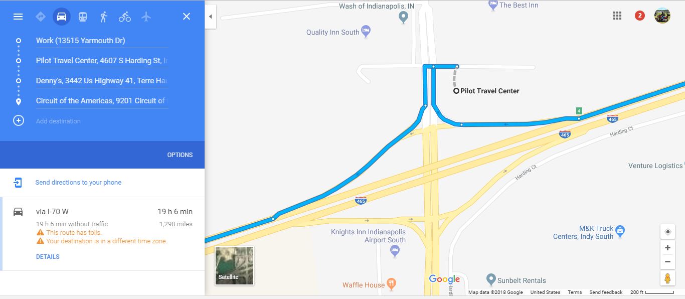
The first thing I did was locate an interstate exit that looked to be about the right distance and clicked-and-dragged the route to the surface road (in this case, US 231 at I-70). I then right-clicked on the little dot, made it a destination, then moved the new destination between Terry Haute and Columbus.
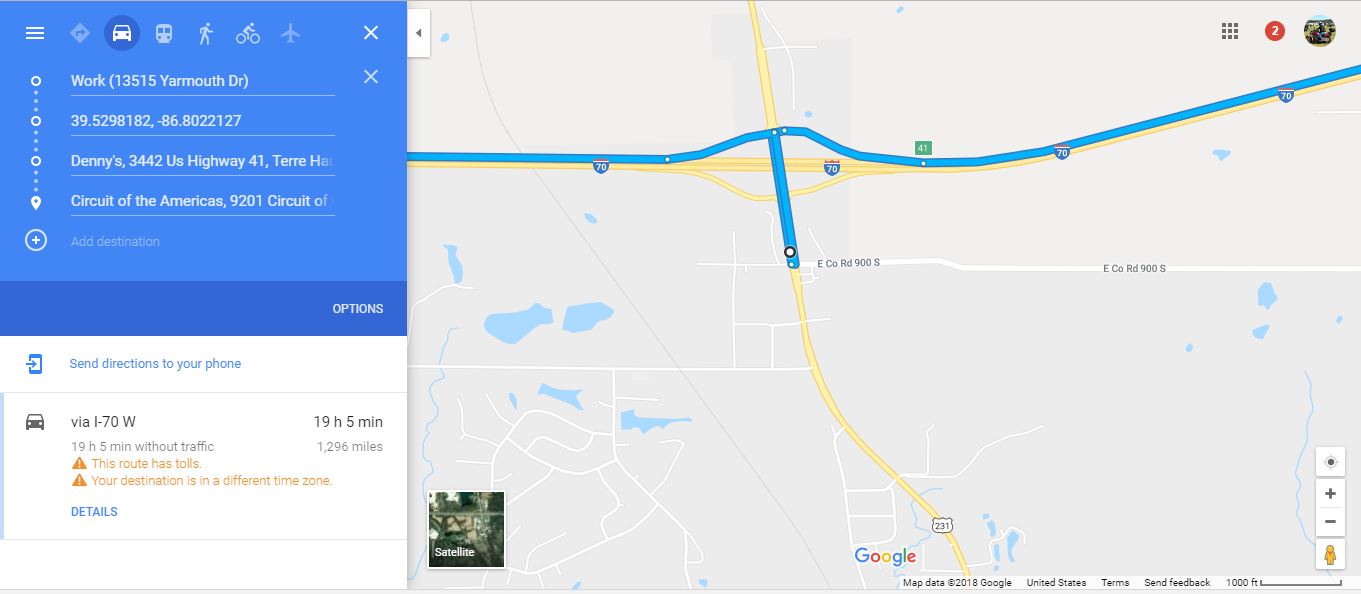
Unfortunately, this stop, while having several gas stations, is too far from our starting point (229 miles). I then pan eastwards looking for another suitable exit and use the exit numbers to roughly figure out how far east I need to pan (40 miles or so). This takes us back into the Indianapolis metro. From experience, I know that there is an exit off of I-465 on Indy’s south side that has several gas stations (I-465 Exit #4). So, I pan over to that exit, highlight and delete the old location for the fuel stop on US 231, and click on the Pilot Travel Center on the north side of I-465. Google Maps tells us that the Pilot is 194 miles from our start point (still inside our fuel range) and is only adds three miles to the trip length. This would be our first planned fuel stop for this trip.
Our next stop would be Terry Haute to see the old friend from high school. Terry Haute is only 73 miles from our fuel stop, and much too soon to stop for fuel. We will count the stop as a rest stop and look for the next fuel stop. Keep in mind we are looking for a second fuel stop that is 185 miles or so from the last fuel stop, not from our stop to see our friend. Using the same technique outlined above, I found several gas stations off of I-57 Exit #116 (https://goo.gl/maps/ji1DLwaJYFn).

Now we need to pick where our first overnight stop will be. With stopping time, we are looking at roughly 8 hours of travel time each day. Since we decided we do not want to push too hard and will do this trip over 3 days, we will need a total of two overnight stops. Do not forget to factor in the longer stop in Terry Haute to see our high school friend.
After our second fuel stop, we will have approximately an hour of riding left for the day. About an hour south on I-57 we find a Comfort Inn near Marion, Illinois (https://goo.gl/maps/6T8bPGWWUZ82). We can use our American Motorcyclist Association or Motorcycle Sport Touring Association membership to get a discount on the hotel room. To finish this trip plan, continue using the techniques outlined above until all fuel stops, rest stops, and overnight stops have been plotted.
One of the most important parts of planning fuel stops is finding locations that have more than one gas station. Why is this important? Say you’re riding through Wyoming on I-80 where the cheap gas is 50 to 100 miles apart. You do your trip plan and start into the trip, only to find the only station near a planned stop has gone out of business. There isn’t another station right off of the interstate for 50 miles in either direction. If you’re close to reserve and do not have 50 miles of fuel range left, you’re screwed. If you had selected a different exit with multiple gas stations, one of them being closed is not a big deal. In situations where an exit with more than one station is not available, try to pick a cluster of them spread over several successive exits. You may have to ride backward to the last open station you saw. However, it would only be a few miles the wrong way, and a minor inconvenience compared to running out of gas in the middle of nowhere.
Conclusion
The directions above may seem complicated and laborious. They can be, but better to put in the work before you leave than have to try salvaging your very first tour. Once you have a couple tours under your belt or know areas of the country well enough, you may not have to plan as much. However, with a plan in place, it is much easier to figure out which assumptions you had about touring were not as expected, as well as figure out what to do different on your next tour.


Leave a comment