This is a bit of a homer piece, but Ohio isn’t as flat and boring as many think. Yes, large parts of central, western and northeast Ohio are well-glaciated terrain, but southeast Ohio is home to some of the best motorcycling roads I’ve ridden.
Here–in no particular order–are a few of my favorite Ohio motorcycling roads:

State Route 83
Google Map Link: https://goo.gl/maps/qjnwkqTSUamhNatM6
Length: 103 miles
This isn’t the most technical or most scenic route in Ohio, but it’s one that is near to my heart and a blast to ride. State Route 83 has its northern terminus at U.S. Route 6 near the Lake Erie shoreline in Avon Lake, Ohio, but the fun part of the route starts just south of Wooster, Ohio.
From the BP station at the corner of Dover Rd., Millersburg Rd., and Madison Ave., head south on Route 83. I divide up Route 83 into four sectors. Sector 1 runs from Wooster to Millersburg, and features some lazy sweepers and some OK scenic views. The party really gets started in sector 2, which extends from Millersburg to Coshocton. It’s not technical, but it’s a bunch of sweepers with lots of change of direction and some fun elevation change. There’s a set of switch backs just before you get to Coshocton.
Route 83 runs concurrent with U.S. 36 and Ohio Route 16 on a divided highway around the downtown Coshocton and right by Roscoe Village (a neat canal-era living history museum with some good restaurants). South of downtown, Route 83 splits off from Route 16 (start of sector 3, arguably its most fun section). The sector features lots of sweepers and one set of corners I call “Ohio’s mini corkscrew” (if you hit that corner even a little too fast, you’ll know which one it is real quick). One of the best sets of curves is right before you get into New Concord.
South of New Concord (which marks the start of sector 4), Route 83 crosses I-70 then continues the barrage of sweepers for another about 35 miles to the Route’s southern terminus at State Route 60 near the Muskingum River village of Beverly. The Route overlaps with two other Ohio state highways: Route 313 in Claysville and Route 78 (discussed below).
The route has a special meaning to me because it was the best road I could reach within a reasonably short ride when I lived in Brunswick, Ohio. Route 83 intersects with Interstate 71 at exit 204, a little more than 20 miles from the Brunswick exit. I had to ride through some of the flat country to get to where the fun starts, but it was a much shorter than the other roads mentioned in this article. I’d ride south to either U.S. Route 36 or Interstate 70, then head east to Interstate 77, which took me back north to Columbus.

State Route 78
Map Link: https://goo.gl/maps/6ibERh2Z5bgxTeBQ8
Length: 104 miles
If you’re looking for a technical road to ride, State Route 78 is nearly non-stop sweepers, twisties and off-camber corners from Nelsonville to the Ohio River. Do not try to ride at your usual back road pace your first time on this road; you will quickly find your limit. I’ve only ridden Route 78 eastbound as part of a loop Route with Ohio Route 800 (discussed next).
I start my rides on Route 78 at it’s junction with the U.S. Route 33 expressway, near the road’s western terminus at Ohio Route 691 and old Route 33. Other than the few villages the route passes through, it nearly non-stop curves and elevation change for the more than 100 mile ride to its eastern terminus at Ohio Route 7 near the Ohio River.

State Route 800
Google Map Link: https://goo.gl/maps/j3i8ydckkPByY3NL9
Length: 74 miles
While most of this route is twisty-fun ride, it’s the southern end of the Ohio Route 800 that makes it an unforgettable road. I’ve only ridden Route 800 south to north, and only once started my ride at its southern terminus at Ohio Route 7 in Fly. Route 800 steeply rises from it’s terminus along the Ohio River up a steep hill with several switchbacks. It’s a demanding few corners, but the uphill angle lets you push your motorcycle through corners harder, which really increases the fun factor.
The remainder of the route consists of sweepers and twisty bits as the road makes its way north through Ohio’s Hocking Hills. The best riding is on the section of the route south of Interstate 70. Route 800 runs parallel to the interstate for a short ways until turning north again. It’s northern terminus is on the south side of Canton, but the fun riding on Route 800 really ends about where it intersects with U.S. Route 250 in Uhrichsville.
Since I live in Columbus, I usually take this route from Fly to Interstate 70, then head home from there.

State Route 164
Google Map Link: https://goo.gl/maps/4QYRk7nrThH2Q2tJ6
Length: 44 miles
This route is tucked away at the northern end of Ohio’s rolling hills, but is one you’ll keeping going back to once you’ve ridden it. The northern terminus of Ohio Route 164 is in North Lima, but it doesn’t get twisty until you get south of Lisbon. I’ve only ridden the road southbound from Lisbon. Don’t let the first few miles of gentle sweepers deceive you. The more aggressive sweepers and switchbacks with start coming quickly, and it’s that way for the most part all the way to the route’s southern terminus at Ohio Route 212 near Leesville.
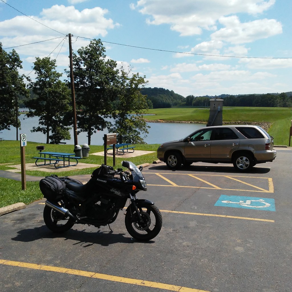
I recommend staying on Route 212 west–which features some gentle sweepers and a scenic view of Atwood Lake (see header photo)–to Interstate 77. Another option is to take 212 to where it splits with Ohio Route 39. I haven’t ridden it yet, but it looks like a fun ride that takes you to the southern terminus of Ohio Route 9–a legendary Ohio motorcycle road that I have yet to turn a wheel on.


Leave a comment