I credit my love of motorcycles for providing the motivation to discover some amazing scenic views. If I hadn’t started riding, I wouldn’t have had a reason to travel through the areas where I found many of the places listed below.
There’s something very peaceful and serene about enjoying a stunning view of the earth’s landscapes, and even more so on two wheels. One recent experience I had with scenery and riding was last year on my trip home from the MotoAmerica event at VIRginia International Raceway. While the best scenic view on the trip isn’t along Interstate 77, I found myself doing more than just looking at the majestic, never-ending stream of tree-covered mountains the interstate winds its way through. I wasn’t just seeing the mountains. Because I was exposed to the elements and not stuck inside a metal box on four wheels, I was–in a deeper, more impactful way–experiencing the the landscape I was riding through.
It’s often the same way with a scenic overlook. When you stop at one while driving a car, you get out and it feels like a different world. On a motorcycle, you’ve already been exposed to the elements of the environment within which the overlook exists. You don’t feel like you’re in another world; the view is part and parcel to the environment you’re experiencing as you ride.
Here’s a short list of the best scenic views I’ve discovered on a motorcycle.

Miller Motorsports Park/Utah Motorsports Campus
Location: Grantsville, Utah
Google Map Link: https://goo.gl/maps/RE8uwHyQNPsD6nyy6
One of the most scenic places I’ve ridden to–perhaps the most scenic–is a road racing facility. Utah Motorsports Campus (a.k.a. The track formerly known as Miller Motorsports Park) sits on the floor of the Tooele Valley, about 30 miles southwest of downtown Salt Lake City. While the track and its associated buildings are nice and all, it’s the view of the surrounding mountains and Great Salt Lake that earn the track a place on this list.
The track’s location features stunning views of the snow-capped Oquirrh Mountains to its east and the dry Stansbury Mountains to its west, as well as a splendid view of the mountain and lake to the north (from the track’s higher elevation areas).


Lovers Leap
Location: Meadows of Dan, Va.
Google Map Link: https://goo.gl/maps/A5CgrRBTEYqWuXLf7
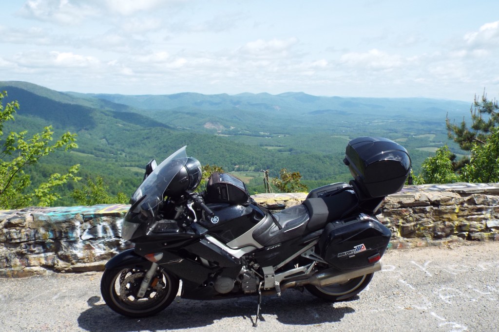
I found this view the first time I went to VIRginia International Raceway to cover a MotoAmerica event, and have been back to see it every year since 2016. The overlook is part of U.S. Route 58, which is a very fun road to ride.
The overlook offers a stunning view of the Blue Ridge hills, and is not too far away from the Blue Ridge Parkway’s interchange with old U.S. Route 58 at Meadows of Dan, Va. There’s no MotoAmerica event at VIR for 2020, but I’m still going to take a ride to Martinsville, Va., or Danville, Va., so I can enjoy this amazing road and view for the fifth year in a row.
You can read more about Lover’s Leap on the Virginia Tourism Corporation website at https://www.virginia.org/Listings/OutdoorsAndSports/LoversLeap.


Cherohala Skyway
Location: North Carolina/Tennessee Border
Google Map Link: https://goo.gl/maps/59wAee6WZoWwXDQp7
This is a well-known scenic road, but it’s still worth discussing here. The about 50-mile parkway was completed in 1996 and features more than 4,000-feet in elevation change from its western terminus in Tellico Plains, Tenn., to the highest point along the route.
All along the parkway there are scenic overlooks to enjoy, as the road is a designated National Scenic Byway. It’s name is a portmanteau of the two national forests the road goes through: the Cherokee National Forest and the Nantahala National Forest.


Hawk’s Nest
Location: Port Jervis, N.Y.
Google Map Link: https://goo.gl/maps/fwZYuGTH19c8hrCbA
Have you ever wanted to ride through one of those short, twisty sections of road you see in motorcycle advertisements? Well, this is one of them, and it has a great view of the Delaware River to boot.
If you live near or are riding through New York City or the Catskill Mountains, you’re not far from Hawk’s Nest, a string of short curves cut into a rock face along the north/east bank of the river. The twisty section of the road is short, but its visual appeal–coupled with the commanding view of the river gorge–make this a great place to shoot some photos of your bike.


Lake Chautauqua Rest Area
Location: Bemus Point, N.Y.
Google Map Link: https://goo.gl/maps/U956wnAki1zZ78Lo9
Though my memories of my early riding days aren’t what they used to be, I’m pretty sure this is the first scenic view I discovered while out riding. The overlook is part of a rest area on eastbound Interstate 86 near Bemus Point, N.Y., on the eastern shore of Lake Chautauqua. The rest area is at the peak of a hill, about 150 feet above the lake’s shore line. A parking area existed at the site as early as the 1970s and the modern rest area was constructed in the mid-2000s.
I found this view in spring 2009 while out on my last ride with my 1997 Honda Nighthawk 750 before I listed it for sale. I stopped just to get a break from riding, and was blown away by the view of the lake and hills. I try to stop at the rest area at least once a year, as well as take my bikes there for a new-to-me bike photo shoot.


Leave a comment